Advanced Search
The church owned another cemetery on Wendover, near the intersection with Marvin Road. According to an article on page 20B of The Charlotte Observer on 9/28/1977, there were several stones on the property. One was marked Anne Kinto, 1/30/1888. A member of the D.A.R.
Revolutionary War era Cemetery, northern half of South Tryon and College Street between Martin Luther King Blvd. and 3rd St., Charlotte, NC.This location has no evidence of a former cemetery.
The church was established in 1880. It was in what was then called Allen, NC, but it is now part of Charlotte. The Carolina Room has listings of those buried before Spring 2001. This survey was done by Paula Griffin.
This cemetery was established in 1971. The cemetery office is in Charlotte. Contact the office first for help in finding particular graves. It is on the west side of Beatties Ford Rd. near the intersection with Hambright Rd. It is visible from Beatties Ford Rd.

This cemetery is owned by the City of Charlotte and was originally designated for African-Americans. In a 1893 report from the Good Samaritan Hospital, some of the patients who died that year were buried in Pinewood in the Hospital lot at the expense of the hospital.
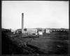
Highland Mill #3 was the largest and most imposing cotton mill erected in Charlotte. It opened in November 1904.

The U. S. Rubber Company, locally called the “Shell Plant,” was located 10 miles south of Charlotte on York Road in the Steele Creek area of Mecklenburg County.
This cemetery was near an early Mecklenburg County poor house. Some researchers believe the dead were victims of the Charlotte small pox epidemic in 1896. ON 4/16/1954, 28 African-Americans remains were moved by the Board of School Commissioners from this cemetery to Sec.

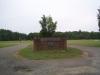
Please see the survey done by the Charlotte - Mecklenburg Historic Landmarks Commission (www.cmhpf.org). A marker has been placed near the entrance to the apartment complex designating the location of the slave cemetery and is shown in the photo.
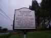
Survey was done by William J. Charles survey for the Mecklenburg Genealogical Society, on 2-14-1983. This cemetery has a large sign at the entrance on Hildebrand St.
In 2004, it was reported that these graves might need to be moved for the Lynx Blue Line.This cemetery of unknown origin is north of the China Grove AME Zion Church property and appears to have 12 graves.
Documentation
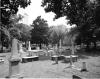
This cemetery is owned by the City of Charlotte and is the largest cemetery in the county. It was organized in 1851. Section K was divided by 3 early churches-First Presbyterian, Second Presbyterian and Brevard St. Methodist. Originally, the cemetery was for whites only.
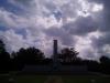
This cemetery is owned by the City of Charlotte. It has a large memorial at the entrance to Mecklenburg County soldiers who died in World War II. The Carolina Room has the microfilm of some burial cards. This cemetery entrance is visible from the street, but no tombstones are visible.
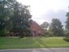
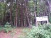
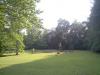
It is located on Charlotte Mecklenburg property parcels as #10109128. The cemetery is in a wooded area behind the church and is not visible from N. Sharon Amity, due to the thick vegetation. The church is directly across the street from the Queen City Apostolic Church.
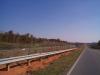
This cemetery was originally where I-485 runs through Charlotte/Pineville. It was relocated to the James K. Polk State Historic Site. The photos will show both the approximate location of the original site as well as the relocation. The James K.
There is information about this cemetery in Hunter's Sketches of Western North Carolina and Foote's Sketches of North Carolina.
Documentation
According to the church secretary, it dates back to the 1930s or possibly before, but Nancy Spaine from the United Methodist Archives in Charlotte said a Methodist church previously owned the cemetery and sold it to Thrift Baptist Church. There appear to be some unmarked graves.
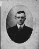
Carson Moore was the uncle of Lois Moore Yandle. He left the mill in 1916 and joined the Charlotte Police Department.
 and South County Regional Library (1998)")