Advanced Search
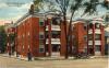
The Colonial Apartments were located at 512-616 North Tryon Street. Physical Description: 3x5 Publisher: CT Photoshop
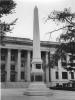
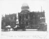
The fifth Mecklenburg County Courthouse is located at 700 East Trade Street. It first opened in 1928. Shipp Monument is in front. Physical Description: 8x10 glossy Publisher: Unknown
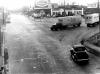
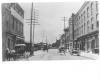
Look south on Tryon Street from Dalton Avenue intersection. Physical Description: 8x10 glossy Publisher: Unknown
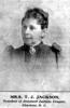
Mary Anna Morrison Jackson (1831 - 1915) was the second wife of General Thomas `Stonewall` Jackson. She made her home on Trade Street following the death of her husband in 1863. Physical Description: Publisher: Unknown
This courthouse was located on the site of Liberty Hall, at the corner of Tryon and Third Streets. Physical Description: 8x10 glossy Publisher: Unknown
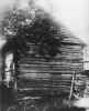
When General Cornwallis invaded Mecklenburg County in 1780, a number of skirmishes between the local rebels and the British troops took place. The Battle of McIntyre's Farm took place on October 3, 1780. The log farmhouse was located on Beatties Ford Road.
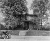
Home of Captain William R. Myers at 802 East Avenue. (Information listed on original photograph is incorrect.) Physical Description: 8x10 glossy, 4x5 negatives - 4 copies Publisher: Unknown
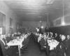
Firemen meet for dinner on the second floor of the City Hall in 1916. Physical Description: 8x10 gloss, Publisher: Unknown
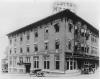
The Clayton Hotel was located at the northeast corner of Church and Fifth Streets. Built in 1913, the hotel offered one hundred rooms and fifty baths. Merton C. Propst was the owner. The Clayton Hotel was demolished in the mid-1970s to make room for a parking lot.
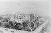
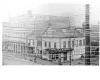
Photograph of the architectural rendition by Charles C. Hook for three government facilities. The City Hall is in the center, the Fire Station to the right and the Police Station complex is on the left. The facilities were built and occupied by the fall of 1925.
This historic marker is the site where Jefferson Davidson stood on Tryon Street when he learned of President Abraham Lincoln's death on April 15, 1865. Physical Description: 8x10 glossy Publisher: Unknown

Looking west on Trade Street, past the Church Street intersection, one can see the Selwyn Hotel on the right. Physical Description: 8x10 glossy Publisher: Unknown
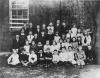
Students in Mrs. Agnes Todd's Fifth Grade Class at D.H. Hill School posed for this school picture in 1915. Physical Description: 8x10 mounted Publisher: Martha Warsham
The Wiggins Brother's Wholesale and Retail Store was located at 200-206 East Bland. Jasper P. Wiggins was President of the Company and ran the company along with his brothers: Joseph W. Wiggins, Vice-President; Thomas J. Wiggins, Secretary; and John L. Wiggins, Treasurer.
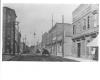
Looking south on College Street from the intersection of East 4th Street. Physical Description: 8x10 glossy Publisher: Unknown
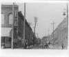
This photograph captures the activities on College Street while looking north from East 4th Street. Philip Carey Manufacturing is on the left at 216 South College Street. They sold cement, roofing materials and pipe coverings. The Klueppelberg Grocery Company was located at 201 S.
Looking north on College Street from the intersection with East Trade Street. The Bee Hive, on the left, was located at 43-47 E. Trade Street. It was a fashionable dry goods, clothing, shoes and millinery store. Physical Description: 8x10 glossy Publisher: Unknown
This photograph was taken during an ice storm on December 14, 1890 at the northwest corner of Trade and Tryon Streets. Visible are Samuel Wittkowsky's Dry Good Store and the A.B. Reese Company, a pharmacy. Physical Description: 8x10 glossy Publisher: Unknown
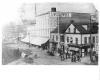
Late nineteenth century image of the northwest corner of the intersection of Trade & Tryon Streets (The Square.) Notice the covered wagon. Physical Description: 8x10 glossy Publisher: Unknown